Wednesday, January 30, 2013

Safe in the Sounds

I may have made my first major mistake of this New Zealand escapade: I only spent a single day in Wellington.

Leaving Turangi on the very crowded Nakedbus on Monday afternoon, I caved and got the first McDonald's meal I've had in a scattered while. But, I wanted to check my email (they have free WiFi here in this country), and I got to try a New Zealand-exclusive Kiwiburger (it's like a Big Mac, except with a fried egg and beetroot on it). The whole trip into Wellington took about 6 hours, going through some mountainous country, compact city-towns, and eventually a long strip of the Pacific Ocean as we rounded off the southern tip of New Zealand's North Island. A few traffic jams later, we stopped alongside the docks of Wellington Harbour.

New Zealand's capital city is a lot smaller and more compact than Auckland, with less than 400,000 people. It's walkable, built into the hills surrounding a harbour, and is otherwise known as “Windy Wellington” – is it any surprise I found a natural kinship to the place? And to prove I wasn't just jumping to conclusions, I met up with a girl from New Brunswick for drinks, and having lived here for a couple months, she claims the spot reminds her of Halifax. Halifax and St. John's have always had a natural connection in my mind, and after spending a few hours roaming the city and watching the very orange full moon rise over the harbour, I decided that Wellington belongs to a fairly exclusive list of cities around the world that I would actually enjoy living in.


So, having just a fragment of the afternoon to have Wellington impress me, I had to make it count. I thought about Te Papa Tongarewa, the national museum not far from the hostel where I was staying, but I've heard that the museum is so large, thorough, and entertaining, that you'd want a full day there. I might as well do it right – so that's on the list for next time (although this cool exhibit on the history of video games might well be finished by the time I make it back this way). I wandered until I found myself at the Parliament Buildings at the end of Lambton Quay, a collection of buildings from the Gothic-style Library to the Beehive, the Executive Building whose colloquial name is no surprise when you actually size the thing up. Again, I thought about taking the free tour, but time was of the essence, and it was the kind of sunny day that you'd rather spend outside than in a Government building.


So I went looking for the Wellington Botanical Gardens, 25 hectares of trails along the hillside that offers views of the city, plus a whole lot of trees and plants that a botanist could tell you all about, and a goofball like me could tell you were different colours and sizes. The Lady Norwood Rose Garden, just one part of the Garden, has over 3,000 roses, with 110 different beds set in a circle around a fountain.


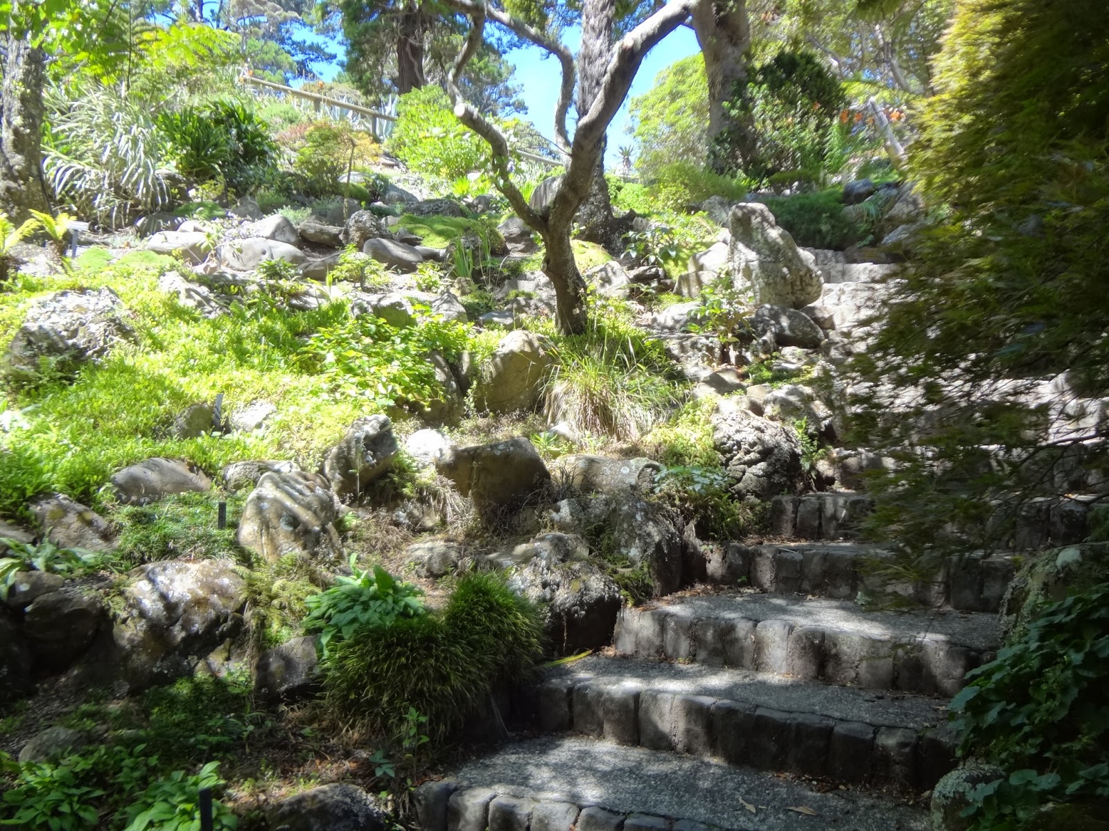
Plus, in between a few modern art sculptures, there was a bizarre, fully functional Sundial of Human Involvement. Bonus points if you can figure out how it works.

Hint: that column in the middle has months and dates on it

But before I could get here, I had to find it. I mean, I just showed you a couple of pictures from it, so you can guess that I got there alright, but humour me. My one complaint with Wellington is its lack of signage. Maybe I'm just stunned, I don't know, but I'd be at intersections and not know what street I'm on because there's no sign. Or I'd be looking for a significant city landmark and have nothing to point me in the right direction, making it tough even with a map.

Just as I figured I had run out of time, I found the station for the Wellington Cable Car. There are two red, Swiss-built cars that ascend a 120 m slope overlooking the city, taking about 6 minutes from bottom to top. I hoped on one of these, made a quick pass through the Garden, then back to the bottom of the hill to get my bags at the hostel and get checked in for my Interislander ferry.


When I got dropped in Wellington the day before, the bus stopped near the docks, and I assumed that this was where I'd be leaving from the next day. So I timed it in my head, and had my itinerary all planned out. You know my ferry terminal was not only unmarked, but an extra kilometre down a busy motorway. You know it was a blistering hot day that I had to start running in, my entire backpack on my back with the detachable daypack swinging around haphazardly with each sprinting step, throwing me just a little bit off balance until I ripped it off and started wearing it around my front like an over-sized fanny pack (I might as well have put on my wide-brimmed hat with some socks and sandals, just to complete the image). You know that when I spotted my ferry it would be moving and have people all on the decks, and you know I ran harder then, hoping I remembered the drivers go on the left hand side so I wouldn't just duck out in the middle of traffic.

You probably know that it was my ferry I saw, but that it was just arriving from the South Island. So after I nearly collapsed at the arrivals desk and threw my drivers license at them like it was a hand grenade, I had to wait for about half an hour in the terminal with the civilized people, feeling like Rambo bursting into a funeral.

So long, Wellington. You grabbed a chunk of my soul though – I'll be back. Pinky promise.


The passage across the Cook Strait on Arahura takes 3 hours to go 92 km, and it's a ferry ride unlike any other ferry ride (not just because there was a juggling troupe onboard). It feels like one of the world's best-kept secrets; the route leaves the enclosure of Wellington and slips around the tailend of the North Island, passing through the open waters of the Strait. At no point though are you totally tossed to the ocean – land is always in sight in one direction or another. It seemed distinctly New Zealand, to have Wellington fade in the distance behind us as I looked at a freight trip full of, you guess it, sheep.


But it's the South Island that captivates you. The hills start approaching, covering the horizon, and they're covered in this light mist that makes you feel like you're stepping into a storybook world. In some ways I guess you are. Then, they fill your vision, and suddenly you're in them, weaving your way through the narrow channels of the Marlborough Sounds (in particular, the Queen Charlotte Sound). Look at a map of the area to appreciate how this entire section of country is bordered by a labyrinth of drowned valleys rising to green rolling hills.


The North Island seemed a lot farther away already, like you're being lulled to sleep and having a dream world slowly close in around you. The Cook Strait is not particularly wide, but it's the gulf between two very different worlds.


Once we arrived in Picton, the InterCity Bus was waiting, heading with a small crew to Nelson. Nakedbus and InterCity are the two national bus lines, and having travelled on both I had a much nicer experience with the latter –the seats were roomier, and the driver acted as a tour guide, which was especially nice as we went through some radically different landscapes.


First, the vineyards. This is wine country, here in Marlborough, and the rows and rows and rows of grapes just stretch on forever, into the hills. Three hundred thirty billion, if the driver is to be believed. After leaving Blenheim, we went up into the valleys, where farming took over – sheep, cattle, even alpacas (so now I don't have to go out Stephenville way when I get home to see those weirdos). Pulling over on the side of the road, we came to Havelock, a tiny town built around a small bay at the mouth of the Sounds, and the self-proclaimed greenshell mussel capital of the world.

With hills all around, Havelock is what you think of when you think of the middle of nowhere. But maybe that's an ok place to be right now – wasn't it the Cheshire Cat who said that if you don't know where you're going, any road will take you there? This is my jumping off point, a point to gather my thoughts and plans and embark on the South Island part of my New Zealand adventure, with roads going in either direction. I'm working for accommodations at the Blue Moon Lodge, sharing a dorm room with 5 other workers from around the globe (though Germany is disproportionally represented) – it's not the height of luxury, but with just a few hours cleaning, watering the gardens, and looking after some youngsters on the swing set, it's not exactly hard work, either.


We even ended up on a walking trail through the woods last night, keeping our eyes on the hillside around us to see a vast lattice of glowworms – insect larvae giving off a little pinprick of luminescent light. At one point the hill stretched a good 20 feet into the night sky, presenting a brilliant Lite-Brite display that was like being in space rather than just looking up at it.

Kind of like being in a lucid dream, drinking wine on a sunny deck and hidden from the rest of the world in the Marlborough Sounds.

Cheers,
rb

Monday, January 28, 2013

Simply Walking into Tongariro

I've heard tell of baptism by fire, but it takes having patches of skin looking like boiled beets (or just regular beets, I guess . . . anything red I s'pose, if you want to play Choose-Your-Own Metaphor) and legs that feel like they're ready to fall off to really get what the phrase means.

But I'm getting ahead of myself.

Leaving the Bay of Plenty on Saturday morning, I had a front row seat through the kiwi orchards of Te Puke, the sulphur-smelling hot pools of Rotorua, the Whakarewarewa Forest Park (when you're attempting to pronounce these Maori names, “wh” sounds like “f”), climbing steadily up the Plateau, through the lakeside city of Taupo. All along the road, with two lanes and sharp turns, there are safety signs, with anthropomorphic kiwifruits boinking into trees – which is cute, until you think about what the fruit is representing. A few short hours later we made it to Turangi, where we stopped for a coffee and some buns. The town itself is small, so it didn't take long to find the A-Plus Backpackers Hostel, where I jumped out of one caravan and moved to another.


“Now Ryan,” Jane said, giving me a patented Grandmother hug, “be careful, have fun, and don't do anything stupid.”

And with that, I'm off again.

I use the term “shanty town” in the most endearing way possible when I talk about Turangi. It's small, spread out, a little bit dishevelled, but has the Tongariro River bordering it on one side, and the peaks of the slowly ascending mountain range on another. A-Plus Lodge is, without doubt, the shanty. I guess you'd call it open-concept, with a field for tents occupying one corner, a lounge/kitchen/reception area that has a few walls but is open to the parking lot and the garage, and the whole thing is surrounded by a fence where the perpetual backpackers have painted pictures and poetry. It felt like I stepped into a hippie commune, a revolving door of people out searching for themselves where the real world ceases to exist.


Again, I say it in the most endearing way possible. Ian, the owner, lives here with his family – his barefooted kids might not have all the luxury of Eloise, but with the steady flow of people coming through this weird little microcosm, I bet they have a lot more stories and adventures.

One last thing about the A-Plus Lodge – I don't usually divulge any of my heinous hostel bathroom stories. I've got a few, probably enough for another blog, which I should really think about doing someday – this one, though, needs to be shared right now. So I get there, get semi-settled, and plan to go pick up some groceries with the German girl who's in the same room. I just would duck to the washroom first.

The toilet has a single flush rod on it, extending from the front of the tank and able to revolve in a complete circle. I turn it around a few times, and nothing really happens. I eventually hit on the right spot, and a dribble of water comes out. Now, I've worked at a kids summer camp for most of my teenage life, where you either learn how toilets work or you land yourself in deep trouble. I took the lid off the tank, and saw that something was very, very wrong with this setup.

But, I had a weird arsenal of tools at my disposal. A sippy cup was floating in the tank, and there was a little garbage can (the one piece of good luck I had in this whole misadventure was that this was empty). So, through trial and error, I devised a system where I'd fill the sippy cup from the tank, empty it into the garbage can, and then when I had enough water to create a suction flow, I'd dump it into the toilet bowl.

About 17 minutes later I came back, one arm dripping toilet tank water up to the elbow, and pretended to pass it off like nothing happened. Things improved after that.

People who come to Turangi generally come to hike (“tramp” in New Zealand) or fish on the river, so even though the hostel was nearly empty this weekend, the shuttle bus going to the Tongariro Alpine Crossing was packed. It only takes about half an hour to reach the car park, at the end of Mangatepopo Road. There are a number of tracks that run through this area, going as far as the ski fields along Ruapehu; the main one that people do in a day is the Alpine Crossing, which starts here and ends at another car park near Lake Rotarira, some 16 km away. It takes the full day, and is widely touted as the best full-day tramp in New Zealand, and one of the best in the world.

We couldn't do that, because there's been some volcanic activity on Tongariro (one of the three main peaks in the area, the other two being Ngauruhoe and Ruapehu, all in a neat little line), but there was an option B; rather than just reach a certain point and turn back around, we could hook into the Great Northern Circuit which wraps around the other end of Ngauruhoe. It would take a little while (the Department of Conservation runs a bunch of self-contained tramping huts throughout New Zealand, where hikers can stay for the night – there were two along this route), but it wasn't too crazy, right?


Roosters were literally crowing when we left Turangi around 7:00, dressing in layers to fight off the early morning chill that is inevitable at this kind of altitude. Other buses were pulling into the car park when we arrived, but the clusters slowly spread out as we got further along. It wasn't too long before I needed to strip my layers, shoving a jacket, pants, and thermal undershirts in my [almost too small] day pack and welcoming the sun on my bare legs and arms.


I also, at this point, have to admit to being wrong, something that I hate doing. Before I came to New Zealand, my Dad told me to get a wide-brimmed hat. To which radically uncool suggestion I rolled my eyes. Stewart told me the same thing, except with more gusto – he drove me to the store, and basically said that I wasn't allowed to go outside if I didn't buy this hat. Even though there's a hole in the ozone right above New Zealand, and even though this country has one of the highest rates of skin cancer in the world, I still felt stupid – until I put it on and felt my stinging neck sing praises. I don't apologize for being stubborn, but I'll admit to being wrong, I guess.

So, the Tongariro Crossing. To say it's unlike anything I've ever seen before is fairly obvious, since this is such a world onto itself, but at the same time it's something that needs to be said and believed. The trek begins with sparse vegetation, in the shadow of these towering mountains. Slowly, you start climbing along weaving stairs, the sun persisting and your surroundings getting drier and rockier. It's an unreal volcanic area, a cross between a desert and the moon. I won't even stop myself from saying it looked like Mordor, because it was Mordor, with the perfectly shaped cone of the volcanic Mt. Ngauruhoe doubling as Mt. Doom in the film trilogy.


So obviously I had to climb that.

The only problem with climbing Mt. Doom is that there is no trail going up in, only a steep slope sticking 2287 m into the air. Parts of it were easier to get footing, but most parts were just banks of sand and volcanic scoria (I'm pretty sure the only way you can say that in your head is to the tune of “Disturbia”), where you had to pick a zig-zag pattern out to have any chance of making any headway. In the heat and the struggle, my chest was near ready to burst – not that it was easy for Frodo or anything. At least I had sunscreen, a hat, and water.


On the bus, I meet a Korean dude, Noah, who joined me for this leg of the journey, which was a lot better than scaling a volcano on your own. Closer to the top, we joined in with a group from Canada, and about 2 hours after starting our ascent off the beaten trail, we reach the summit. There were two main peaks at the top – we checked out the smaller of the two first, which gave a wicked view of Mt. Tongariro below us, as well as further out, to the Blue Lake and Lake Rotoaira. There was also a vent up here, spewing steam, which fogged up your glasses as soon as you got anywhere near it.


The crater though, that took the cake. Probably a kilometre in diameter and going down in a steep, jagged bowl that makes Mt. Eden look like a child's broken toy, this was what it felt to stand on top of a volcano.


We had our lunch up here, and before I left, I had to do something that countless weirdos before me have probably done.


What goes up must come down – but that doesn't mean it was easy. All the things that were against us going up (the steep slope, the loose rocks) were just as difficult going back down, if not more so. Even zig-zagging wasn't always possible, so sometimes you had to get down low and let yourself slide, being incredibly careful that you didn't dislodge too many large rocks in the process, because Mr. Wilcott taught me enough about physics to know that if a rock the size of your head starts tumbling down a 45 degree slope, it's not just going to stop. Not unless it transfers that momentum to something else – in this case, someone creeping along just like you.


When we finally made it to solid ground, we looked back on the monstrosity we had just climbed and couldn't really believe it. I felt like I deserved a pat on the back for conquering the mountain – if I only knew what was still ahead of us in this desert.

Rejoining the trail we left earlier, we continued, veering towards Tongariro. After another deceptively steep, sandy incline (they never look as daunting or as far from the bottom as they actually are – I thought I learned that once upon a time, on a beach a long way from here), we came to the Red Crater, aptly named. It's a massive gouge in the earth, blood red, and beyond that the Emerald Lakes, and a trail stretching into nothingness. It was here that most sensible people were turning back – and here that we had to make a decision.


Had I been alone, the pure isolation of the road ahead would have driven me insane, and I never would have been able to attempt it. Hell, if I'd really known how far it was, I might have reconsidered even if I had an army with me. But as it was, a little voice from somewhere in the guts of my being called out to me: “There very well may come a day that you need this – when you need to know that you were capable of doing this. Go.”

Another voice, probably the same one that was behind chucking a plastic ring into the crater of Ngauruhoe, remembered that line from The Fellowship of the Ring, where the b'ys are hanging out in Lotthlorien and, as they're leaving this one glade, we find out that Aragorn “came there never again as a living man.” That always stuck out for me because I found that definite closure a bit sad – how many places have I been, people I've met, that I'm never going to see again? Would I have done things differently if I'd known? You can drive yourself nuts dwelling on what could have been, and as I stood at the sign warning day hikers to turn around, bone tired, I knew that if I didn't continue, that road would, for better or for worse, forever remain the one not taken.

Along the way, we went through arid deserts drier than anything I've ever seen, places where you can't imagine life ever existing, the only noise in the still air the buzz of beetles. I saw long stretches of emptiness literally vaster than anything I've ever seen before, enclosed by stone giants and unending at the same time. A kind of beauty so harsh and unforgiving that you feel inspired and terrified and that there's no point in trying to sort out your emotions.


At the Oturere Hut (spacious, with rows of bunk beds, a cabin-style kitchen, and outhouses) we refilled our water bottles from a spring, and braced ourselves for the 3-hour jaunt to the next hut, the Waihohonu Hut, over steep ridges, through an out-of-place forest, and a whole lot more rocks and sand and sun. Even when we made it, we were still an hour and a half from the road, of course called the Desert Road. When you can see as far as we could, it's difficult to imagine distances that long. Conversation that had earlier been centred around cross-culture language barriers and lifestyles (and learning what in the hell “Gangnam Style” is about) were abated somewhere around kilometre 18 as extreme fatigue cut in. With every thudding footstep on the desolate path (when there was a path – sometimes it was just long stretches with the occasional marker to let you know you're going the right way), I just kept thinking, “Oh crap. Is this what Jane would call stupid? Where are we?!

You know how, in cartoons, characters sometimes transform into hot dogs when they're with someone who's starving? I walked 25 km in the New Zealand desert with a 5'4” bottle of Aquafina who spoke broken English. Recognizing this, I opted for the much healthier musing on whether or not I could drink my sunscreen.

The road was a beautiful asphalt beacon, 11 hours after we left the car park. Of course, we were still a ways from Turangi. At our hostel the day before, we had been told up front that Ian would come pick us up if we needed it – but that hitchiking was pretty legit in this part of the world.

Don't. Do. Anything. Stupid.

A few things. I never would have hitchiked in the dark, and certainly not alone. But it was only 7:30 by now, with plenty of daylight left, so I figured we'd humour this ludicrous idea and just ring the hostel after half an hour and get saved. There were long periods of emptiness (did I mention this was the Desert Road?), then zooming vehicles that never so much as slowed down, until an agriculture worker in a company truck pulled over.

“I'm only going to Turangi – I'll take you that far if you promise not to knife me or rob me!”

“Sounds good,” I said, plunking down in the backseat and feeling the weight of the world lifted off my shoulders, hoping the drive would take all night so I wouldn't need to move any time soon. “Only if you'll promise the same thing.”

It was twilight by the time we made it back to Turngi, with the roosters crowing again at the end of a very long day. Over supper, an American couple came (she was from Baltimore and, yes, they have a love-hate relationship with The Wire) and convinced Ian to drive them up to the Tokaanu Thermal Walk, a public walkway alongside bubbling mudpools and smoking vents. I was more exhausted than I've been in a long time, but I went along anyway – my daytrip ended watching the steam of a hot pool rise beneath a full moon, a clear sky above.

“Now, where's the Northern Star?” Ian joked, after pointing out the Southern Cross on the horizon.

“A long ways away,” I said, looking in that direction even though I knew it was far below the horizon. A very long way away – but sometimes, going that extra distance ends up making all the difference in the world.

Cheers,
rb

Friday, January 25, 2013

On the Road Again

I've got one of those 4 digit combination locks for when I move around from hostel to hostel – it's been in my daypack since I came to Tauranga, and after being left open and getting tossed about for the last week, the combination totally reset. I spent about an hour today trying to force the bastard back open and watching enough YouTube videos on picking locks that I'm probably on the No Fly list by now. When I finally cracked it, I was like, “Sick, now I don't have to spend ten bucks on another lock!”

That was until I was like, “Well . . . that wasn't that hard.” I guess I have to hope I don't sleep in a bunk over some guy who's more in-tune with his inner thug than me. These are the kinds of problems I have to deal with these days.

Actually, there's a bunch of different things that I'm going to have to deal with soon. I got used to a regular routine pretty quickly – juice and cereal ready on the table, coffee around 10:00, a light lunch a few hours later, then a beer and Roadies BBQ crisps before supper, which is dinner over here, happens around 7:00 in the evening, and ends with New Zealand ice cream for dessert. All that is getting tossed to the wind tomorrow, when I'm hitting the road and going off the grid, on my own again. I daresay that means dry pasta mix in some squat little kitchen tomorrow night, using water instead of milk.

Once I go to law school, there's no way I can get away with doing anything this cool again.

The plan is to hitch a ride in Stewart and Jane's motor-home as far as Turangi, at the southern tip of Lake Taupo, the biggest lake in the country. The way I've been accepted into their family and shown every ounce of Kiwi kindness is something I never came looking for, and I hope our paths cross again in this mixed-up backpacking adventure.  Along the drive, we'll be going across the Central Plateau, a real geothermal hot spot in the North Island, before creeping up to the foot of the mountains of Tongariro National Park. If the weather holds (and it's supposed to) I'll be embarking on the Tongariro Alpine Crossing, a day-long hike around some spectacular lakes and sharp-tipped volcanoes, on Sunday. It's been ranked as one of the best day hikes in the world, and even though I can't do the whole thing (there was a bit of a blow-up not too long ago – as wild a story as it would be, I'd prefer to not get blown up in a volcano explosion on this trip), I'm expecting to see some cool stuff (and, let's be real, climb Mt. Doom).

Ideally not while this is happening

The next day, it's on to Welllington, the capital city, on the very southern end of the North Island. My stay there (at least this time) will only be short, catching the ferry across the Cook Strait on Tuesday afternoon, where I'll arrive in the tiny town of Havelock just as it's starting to get dark. I've landed a gig at the Blue Moon Lodge for a few weeks, doing God knows what – I do know though that the town sits nicely at the head of the Marlborough Sounds, had a recent population surge of 12 people to bring them to 486 (487 on Tuesday), and is the greenshell mussel capital of the world.

Expect an earful from the next stop on this winding road. See you in a few days.

Cheers,
rb

Wednesday, January 23, 2013

Well, I'm Back From a Hole in the Ground

~ January 23, 2003 ~

Dear 13-year old me,

Sometime in the next two weeks, you're going to pass a man in the mall in Corner Brook with a cane. He's going to drop a pack of cigarettes, and you're going to bend over and pick them up for him. This is the only time you'll see him for 8 years, and this is your only chance to stop him before he comes up with the robots that will take over us all.

Naw, I'm just screwing with you. The future is cool, we use time travel to do stupid gimmicky things like this.

But anyway, the reason I'm writing to you is to reassure you that things work out. I mean . . . ok, you don't get a whole lot taller. Or better at sports. Or with girls. But hey, the guitar . . . no, that skill has pretty much peaked too. But forget all that stuff. Because in ten years, you'll go to Hobbiton, and if you think you'd like that now, imagine how much you will when you're me.

Sincerely,
Me (you)

P.S. Invent Facebook


It was an early start this morning, driving over the winding and hilly Kaimai Range to the green rolling hills of the Waikato. This is picturesque farm country, dairy and sheep, with wide stretches of open land. An early morning sun was shining on Hobbiton, just outside of Matamata and about 45 minutes from Tauranga.

Let's step back for a minute. Back in 1998, when Peter Jackson and the b'ys were scouting for locations for The Lord of the Rings, they flew over the Alexander family's 1250 acre farm, and the first thing they saw was a lake in the middle of a ring of hills, with a massive 100-year-old tree right alongside of it. It was because of the perfect, natural positioning of the Party Tree (or, as it is now aptly nicknamed, the Money Tree) that they ended up leasing this part of the farm from the family, building a mill, a bridge, a brick pub, and 37 Hobbit holes in the hillsides. New Zealand pretty much is Middle-earth, from the fields of Canterbury doubling as Rohan to the volcanic Mount Ngauruhoe (not far from here) as Mount Doom, but the only actual set that remained after the filming of the movies was the village of Hobbiton. Even this spot started as a temporary set, but after The Hobbit was filmed here in 2011, it remained a permanent fixture. People wanted to see Bag End and where the rest of the hobbits hung out, and it turned into a pretty good business venture – the farm around the set is still active, but every 15 minutes a bus load of people are brought around to get their pictures taken in front of Bilbo's house. I went first thing in the morning, and managed to get on a modest-sized tour, but every one after ours was full to the brim. At peak time, around Christmas, the tour group had to deal with some 1500 people every day.

Step back another minute. I really, really wanted to go to Hobbiton – I think I've read one of the books in an airport terminal once, but I can't really remember what they're about. By which I mean to say that I could probably write out all the words to Tom Bombadil's songs if I really tried. 

Seriously? I should have at least tried basketball, I never had to get that good at it . . .

Ok, back to New Zealand.

We started by leaving the main farm road (Buckland Road, which as far as I know has no intentional connection to Tolkien's world) and driving in over a private 1.5 km dirt road, specially built by the New Zealand army before filming. As we went along, passing by the boring stuff like the field where make-up tents and catering tables used to be, the bus driver came on the speaker and said that we'd soon get our first view of the mill by the river.

Pffff no we won't, there's no way I'm really – oh, wait, there it is. Well, I can admit to having those smuggled apricots in my pack and get myself deported, I'm good now.”


The bus unloaded at a gravel cul-de-sac, right by that high narrow part in the hedge where the hobbits make their return from Gondor with some serious swag in The Return of the King (if you're reading this and didn't know that the hobbits make it back alright, don't ever tell me). The village opens up from there, doing a decent circuit around the lake. One of the cool things is the way that the paintings of the sign posts (pointing out which of the four Farthings you're in, obviously), doors, and around the gardens have been made to look lived in, like the village has been here for ages. The tree on top of Bag End was originally brought in from the nearby area in hacked-up pieces, and reassembled like the least fun jigsaw puzzle in the world; Peter Jackson was apparently a real stickler for details, because when it came time to reconstruct the permanent set for The Hobbit trilogy, he had a tree specially made to look identical to this tree (that maybe gets 20 seconds of air time), except that it had to be 60 years younger to fit with the prequel timeline. But, when you've got the millions of dollars the studio is throwing at you (and a legion of fans who will notice these things), you can afford to do things correctly. Right now, the set has several full-time gardeners and maintenance crew, and I don't say they have many idle days.


You're not allowed to touch any of the set materials, but you can get a good up-close view of the holes, most of them being small (for longer shots), but the scattered one that is full size, to create the right movie magic sense of perspective. Up the hill, which gives a wicked view of the lake, the mill, and the surrounding fields (there was only one non-hobbit building visible during filming, and they painted the roof to make it look like a tree), there was one house we were allowed to step into, which just leads to a bare wooden room. All of the interior shots were done in Weta Studios, down in Wellington.


But, we still got to visit Frodo and Bilbo's iconic house at Bag End. And it's here that I have to make a pretty painful, embarrassing confession: I learned something today. Remember that scene where Gandalf and Bilbo are out smoking their pipes facing the sunset over the Shire, right before Bilbo's eleventy-first birthday? Well, Bag End faces due east in real life; they didn't use any special effects though, they just filmed that scene at sunrise and made sure not to linger on the sun actually coming up over the hill, instead of down. Fun fact. 


The tour wound down by the grassy field near the Party Tree, where we found out that during the party scene they served a very low percent, specially-made beer, so that the cast would get caught up in the onscreen revelries but not start slurring their words. 


Once we crossed the stone bridge by the mill (passing Sam's house first, the yellow-doored hole that fills the screen for the final shot of the films), we came to the stone terrace of the Green Dragon Pub, where we got to try some of the slightly stronger beer that is, nonetheless, totally unique to Hobbiton. Seems like a fitting spot to end a visit to the heart of the Shire.


A lot of fanatics have gone through Hobbiton: apparently there was one couple where the wife didn't speak any English, so the husband translated for her. In Elfish. So, I'm able to comfortably put myself somewhere farther down the scale than that, but today was still a pretty major check mark on the ol' bucketlist. Plus, mulling about the Shire and then watching it slip behind the farm hills is almost the perfect metaphor for this trip, trading comfort and absolutes for some wild pursuit to the other end of the globe.

Home is behind, the world ahead,
And there are many paths to tread.
Through shadows to the edge of night,
Until the stars are all alight
Then world behind and home ahead,
We'll wander back to home and bed.”

It'll be a there and back again kind of adventure I'm sure, but I'm only getting started yet.

Cheers,
rb