I've done a bit of hitchhiking in the
past few days, and it left me with a genuine curiosity as to what
someone's reasoning would be for stopping to let a stranger share a
ride with them, but more importantly, why people don't stop
for a hitchhiker. Most don't, and I don't think it's a safety thing.
I assume that most drivers don't even entertain the thought – it's
not a “should I or shouldn't I” dilemma, just an assumption that
someone else is the type to pick up a hitchhiker on the side of the
highway, but surely not me. And I don't say that in a judgemental way – sure, there
aren't a hell of a lot of hitchhikers in Newfoundland, but there are
a few, and I've always passed them with only a cursory thought (if that).
Anyway, just some musings.
The road from Te Anau to Milford, some
100 km, is a lonely stretch through open fields, ancient forests, and
towering mountain ranges. It's beautiful, but there's snow on the
peaks, leaves on the ground, and a coldness setting in – the summer
traffic has gone home, and this 100 km stretch of Highway 94 is
really only used as the route to some hiking tramps and Milford
Sound. In other words, there aren't many cars going by. I assumed
that, for the infrequent driver passing you by, there's a millisecond
thought process that says, “Here's a fellow traveller, heading up
to do some traveller activity (maybe the same one as me), and who
knows when the next car passing through will be?” That's followed
by a release of the gas and pulling over to the shoulder.
Turns out that's not really how it
goes.
Myself and Dorothée
set out on an overcast Sunday morning to hitch up to the start of the
Routeburn Track, another of New Zealand's Great Walks. We weren't
loaded down with sleeping bags and supplies to head into the bush for
a few nights – the Key Summit is a three hour side trip, a 900 m
bump with an alpine circuit that looks out over some glacial river
valleys, mountain peaks, and Lake Marian up in a hanging valley. I
done embarrassingly little tramping since I came to this country, but
now that I've started, I've been inspired to pack my bags and get
outdoors. DOC has said that, if you've only got time for one trek in
the Milford area, make it this one. So be it – but we had to get
there first.
After an hour of no luck, we decided on
a new strategy – maybe the cars weren't stopping for two, so we'd
separate, with me heading further down the road. When you're standing
on the side of the road with a thumb in the air, it's much easier to
be a girl – ideally, Dorothée
would get picked up and have just enough time to make an introduction
and entice the driver to pull over just around the next turn.
Soon enough, we were clipping away with
a tourist couple – from Germany, of course. What a drive. Not
surprisingly, there wasn't a whole lot I could contribute to the
conversation, so I had a chance to have a gaze out the window at
Fiordland unfolding around me. We passed the 45 degree south line,
the mid-point between the Equator and the South Pole if the earth was
a perfect sphere (it isn't), as well as the Eglinton Valley, a
sprawling stretch of lowland bordered by a steep, rocky enclosure of
humility. Spin it any way you want, we're pretty small in a great big
world.

The climb to the Key Summit took a
little over an hour, with wispy clouds shielding some of the more
distant edges of the mountains but still giving a decent view for a
lunch break.


Along the way back, near the edge of
the afternoon, we took a slight detour to Lake Howden, where the
first hut of the Routeburn sits beside the sandfly speckled lake.
After a quick look around, we figured it was time to start trying for
a ride back to Te Anau.


North of Te Anau, there aren't many
places to stay – a few lodgings in Milford, right at the mouth of
the sound (which is technically a fiord), and some campsites along
the road. That's it, so once the day's activities are over, everyone
comes back. That means there's guaranteed traffic – of course, it
also means that once those cars have gone, they're gone.
We stood by the beginning of the Routeburn, on a bend in the road,
for a long enough time for us to seriously wonder what we'd do if we
couldn't get a ride (probably stay in the Lake Howden Hut). A couple
came down from the track and, getting desperate, we started up a
conversation that ended up with us riding along as far as a hotel at
Te Anau Downs, about 30 km north of Te Anau. By now, it was dusk –
the guy offered to drive us the rest of the way, but knowing it was
making him go out of his way, we decided to at least try hitching for
half an hour, and knock on his door if that failed and actual dark
set in.
We'd
pretty much given up and were waiting five more minutes, until 7:00,
when a camper-van pulled over.
Yesterday
morning had a similar forecast, although we made sure to get a move
on a bit earlier. By 9:00 we were back along the same stretch of
road, with the same strategy. I waited on my own further down the
route, and it still took a while, but a French IT specialist
eventually let her join him on his way to Milford, and slowed down
for me too.
The
road gets good and winding and narrow past the Routeburn, as you get
deeper into the Southern Alps. We were equipped for the Gertrude Saddle this day, a longer hike (4-6 hours return) that was also
considerably more difficult, going up a steep mountain pass along an
unmarked route. Clearly it's a less touristy route – we drove right
past the Gertrude Valley first, ending up at the Homer Tunnel, a 1.2
km road that goes right through the Darran Mountains on the way to
Milford.

Eventually we found it, along with clear warning signs to
have your wits about you, and an equally important warning from a
warden that a few trampers got lost and ended up setting up an
impromptu campsite the night before, and that the fine day would
shift to rain by this afternoon. It was just past 11:00 when we set
out over the rocky river valley to the foothills.


Even
knowing it was unmarked, I was surprised at how little DOC had done
to establish a trail. I don't mean that in a neglectful way – this
was just a different experience, an immersion in the wilderness
rather than a sugar-coated walk. A few metal posts let us know we
were on the right track, until we accidentally missed the woods trail
and scrambled along rocks in the dry river bed. We still aimed our
course in the right direction, but it took a bit longer.
When
the wide valley turned into a steep climb, the day was still looking
good, with some awesome views of staggering heights and snow in lofty
nooks. We had a snack break on one of the mini-plateaus that opened
up along the rise, surveying the scene and catching our breaths
before it was back to craning our necks at what lay ahead (and above)
of us.


I said
the trail was unmarked, but that's a bit of a lie. As far as DOC
signposts go, it is, but plenty of other travellers before left stone
cairns to show us the way, up over rock ledges and dips. Obviously
the only way was up, but the markings were pretty necessary to find
the safest footings and most sensible path.


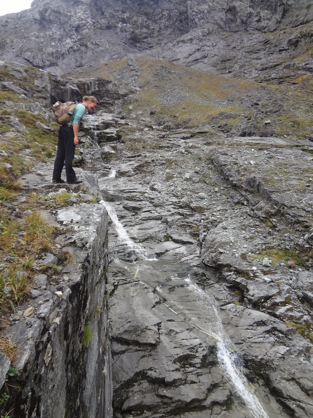
A
glassy waterfall ran alongside us part of the climb, fed from Black
Lake in the reflected shade of more mountain peaks (they don't seem
to end). The large boulders were easier to hop from than the long
smooth rock faces that made up this part of the climb, where you had
to inch your way along slowly to make sure your shoe grips didn't
fail you and you slipped. One close call later (once you start to
slip, there aren't many places to grab hold of), the cairns led us to
a wire rope that made the next little climb a lot easier (and safer)
by giving us something solid to hold onto and hoist ourselves up. It
turns out the rope was even more useful when making our way down the
mountain, but we didn't know that at the time.


Somewhere
below the snow line but into a true mountain setting, the drizzly
rain and wind started. Just in time though, we made the final push to
the saddle, and the view of the valley over 1000 m below and Lake
Adelaide just on the horizon. Deadly place for a peanut butter
sandwich.


Going
down was quicker, but only marginally, especially since the rock
faces were getting a bit slippery. When we made it to the river
valley, we found the spot where we had veered off course, and made
sure that the next group wouldn't make the same mistake by adding one
more cairn to the dozens already dotting the Gertrude Valley and
ascent.

Again,
you'd think two people who had clearly been hiking, here in the
middle of nowhere, would be perceived as a zero threat to a passing
motorist, who would recognize that, being in the middle of nowhere,
it would be a decent thing to give them a ride. Again, not really. We
even had signs to help us, but the sky was still getting darker when
a group of backpackers finally stopped. It was dark again when we
made it back to Des's for some pumpkin soup with a whole new crowd of
faces.

Third
time is the charm they say (admittedly, first and second time were
pretty good) – the two of us were back on the road leading out of
Te Anau this morning again, along with Simone from the Netherlands.
Having three was an added challenge, but far from impossible,
especially since it was early and the boat cruise leaving Milford
Sound was after 1:00.
Ok,
Milford Sound. Piopiotahi. This was something that I've been on the fence about
doing for weeks. If you know one thing about New Zealand, it's that
Lord of the Rings was
filmed here. If you know two things, it's that and the fact that the
Flight of the Concords are the fourth most popular guitar-based
digi-bongo acappella-rap-funk-comedy folk duo from here. The third
thing, though, is that the Milford Sound cruise is something that you
should totally do.
I
guess I was a bit worried that the whole thing would be too touristy
and over-hyped, as the most popular destination in New Zealand. What
you've got is a 15 km fiord cutting into the Tasman Sea and lined
with cascading waterfalls and mountains (the 1692 m high Mitre Peak,
visible from the shore, is one of the most photographed peak in New
Zealand). The “town” of Milford is really just a street with a
booking centre and dock – if you come to Milford, you're going into
the Milford Sound, whether by boat, helicopter tour, or some other
over-priced way.
Fiordland
is one of the rainiest places in the world – fact. We're talking
about 180 days of rain a year, and Milford Sound gets, on average, 7
m of rain a year. In one day, it can get more rain than some places
get in a full year. I've heard that the cruise is nice, even in
dreary weather (imagine the force of the waterfalls then), but if I
was going to do it, I'd want to do it on a decent day.
Anyway,
the three of us made it to the start of the Routeburn with one driver
(he was full of hitchhikers, stopping for a German girl as well), but
we had to divide for the rest of the way, with myself and Simone
cramming into the back of a rented van.

The
sun was shining and the sky was blue at the head of Milford Sound,
and we got onto the first Jucy Cruize of the afternoon, a smaller
boat amongst a half dozen other vessels in the marina. I didn't want
to end up back in Canada in a few months and regret having missed out
on a renowned experience, especially having been so close on such a
perfect day. I'm pretty glad we ended up cruising into the sun.


There
was a gale on the decks, but what a view. You get a hint of it from
the harbour, but actually immersing yourself in it, tilting your
headback to see these peaks – it's something else, something pretty
special. We went as far as Dale Point, an outcrop of land that serves
as the last buffer before the open ocean.


Heading
back, we passed a rock of sunbathing seals; got a shower in the mist
of Stirling Falls, a curtain falling 155 m that is one of two
permanent waterfalls in Milford Sound; and watch a rainbow paint the
opposite hillsides as we rounded the last bend to bring us back to
Milford.


The
rain didn't start until we were nearly back in Te Anau, and by then
it didn't matter. We'd already had a pretty fantastic day in Milford
Sound.


Te
Anau has been a base camp that has permitted me to play in Fiordland
to my heart's content. You could spend ages here, exploring all the
paths (and even more ages going where there are no paths), but my
time in this neck of the woods is drawing to a close, especially now
that some nasty wet weather is making its way down from the north
(Nelson was just battered by some flash floods). Autumn in Arrowtown
is supposed to be spectacular, and Queenstown is an untamed
playground of frivolity and bad decisions any time of the year –
and both are right on my way, wherever it is that I'm going.
Cheers,
rb
No comments:
Post a Comment