I know a lot of people who get really
cynical about birthdays. And at face value, they're not wrong – it
is just another day on the calendar, and you don't really
feel a whole lot different when
you bridge that gap and wake up the next morning. But I don't like
dismissing them altogether, because what better time is there to look
back on the decisions (and consequences) of the last year of your
life, and actually try to make sense of it? Sure, a year is an
artificial time frame, but it's still a time frame, which is the only
incentive you need sometimes.
The
day I turned 23 was a lot different than the one I turned 24, and I
suppose that I was a
lot different, too. The things I'd planned for that year almost
entirely didn't happen, but a whole mess of things got put into
motion that I'm only now realizing and living out. In this detached,
retrospective way, 23 followed a very logical progression, but I'd
never have believed it at the time. I have no idea what this year
will bring (though I, again, have plenty of foolishly optimistic
plans), but I have a feeling that when it comes time to look back on
it next year, I won't be able to imagine anything else but.
For now though, for
this very fleeting here and now, I'm just going with it.
I
don't know when my birthday technically started – I don't think
it was when I woke up on April
15 in Invercargill, since it was still the day before in
Newfoundland. After checking the forecast and finding it at least
passable, Rory gave me a ride 2 hours north, to the little gateway
town of Te Anau. The winds and the rain were up, but we still got
some glimpses into the world of Fiordland that we were entering, with
mountains shooting up in all directions and the highway swerving to
avoid them.


The community sits
right on the shores of Lake Te Anau, the biggest lake on the South
Island (and the second biggest in the country, after Lake Taupo). Te
Anau is where you go when you're doing the Kepler Track, the
Routeburn Track, the Milford Sound Cruise, and half a dozen other
attractions – because of that, it's a crossroads and jumping off
point, deserted by day and a revolving door congestion of the tired,
poor, huddled masses back in the evenings.
After a meat pie
and coffee, it was from one host right to another – Rory's friend
Des is always hosting Couchsurfers in Te Anau (most of them doing one
of the half a dozen attractions on the periphery), and was able to
not only give me a bed on Monday night, but a place to leave my stuff
for when I went off to do the Kepler on Tuesday (named after the
mountain range it traverses, which in turn was named after the
astronomer). So, for my birthday night (it was past 2:34 am NST, so I
guess there were no two ways about it), I ended up drinking wine with
a crowd of Maori sheep-shearers and getting inappropriately hit on by
one of them. I said that this birthday was a lot different from my
last one.
Tuesday
morning had some low-lying clouds, and it was the moment of truth: to
head up a mountain for four days or not? I decided to go for it,
switching out the travel brochures and umpteen changes of clothes in
my backpack in favour of museli bars and a sleeping bag. When I came
out to the living room, there was a towel laid out on the table, and
on it two rows of green jade pounamu straight
from the river bed. Southern
New Zealand is one of the few places in the world where you can
actually find this stuff, and there's a very traditional significance
to them within the Maori culture. It's easy to find carved green
pendants in every tourist shop in New Zealand, but to do it right,
you're supposed to be gifted pounamu,
rather than buy it for yourself.
“I don't often
have someone staying here on their birthday,” Des told me. “Which
one do you want?”
So now, I need to
find a string to wear my pendant around my neck. Whether you believe
that a little chunk of rock can carry spiritual mana in it or not, it
was a significant gift for me, a reaffirmation that people, complete
strangers even, are out there to help you and look after you, if
you're willing to let them.
The first stop was
the Department of Conservation office along the shore of the lake, to
pick up my tickets for the huts I'd be sleeping in along the track
(and some sandfly repellant, a last minute grab that may have saved
my life). It's a 45 minute walk from the town to the official start
of the Kepler Track, with the lakes and the mountains filling your
view every step of the way.


My phone rang on
the very threshold, sometime in the evening of April 15 in Pasadena,
Newfoundland.
“I've said happy
birthday for the last 23 years, I figured I better not stop now,”
Dad said.
And with that, it's
into the wild.


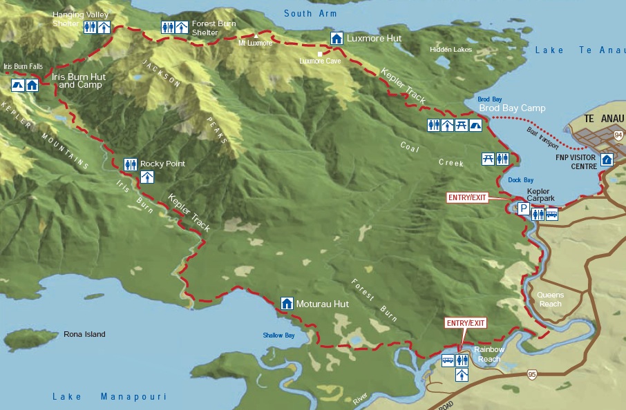
(i) Te Anau to
Luxmore Hut (15.8 km)
You've
got a choice on the Kepler – because it's a loop, you can go
clockwise or counter-clockwise. By far the majority go
counter-clockwise, for reasons that will become evident later on.
Right away though, I noticed something: my shoulders were starting to
ache. The beginning of the track, for the first half dozen
kilometres, goes through a flat forest region – I can't paint the
best picture of the flora, but it was very New Zealand-esque, which
is to say towering trees, ferns, and green, green, and more green.


Even
given the non-existent slope, I knew I had a heavy load, and once I
passed Brod Bay and the forest path made a zig-zagging ascent, I had
to wonder how anyone could go tramping for longer than 4 days,
especially if they had to bring their own cooking gear and pots and
pans. Normally when I say I literally can't understand something, I
don't really mean literally
– this time though, I literally couldn't understand it.
That
epiphany came not long afterwards. I packed way too
much stuff.

As one of the country's Great Walks,
the Kepler has huts that are still being serviced with heat, gas
stoves, full-time rangers (one week on, one week off), and flush
toilets in April. However, I don't mean to belittle it – you're
still going into the wilderness for four days, 60km from the lakeside
to mountain top and back again, and you have to be prepared (there's
no New World midway).
I figured it would be interesting,
maybe even useful (mostly in a what-not-to-do way), to know exactly
what I brought with me on my tramp:
The food. That was the most important
thing I had to think about, because if I had to wear a pair of socks
over again, it's not as bad as if I got to the second night and found
out that I'm out of food. The key is fuel: load up on the breads and
the chocolate, because that's what's going to give you that extra
boost when you need it. I went to the grocery store a few days in
advance and picked up a plastic cereal bowl and spoon, two loaves of
linseed bread, three 200g Cadbury bars, two tins of tuna, three tins
of shredded chicken, an almond snack mix, a 375g jar of peanut
butter, 400g of whole milk powder that dissolves in cold water, a
1.5kg bag of apples, 6 yoghurt bars, two 800ml bottles of water, five
packs of instant chicken noodles, a stick of salami, 500g of
multigrain energy cereal, and a pack of Wrigley's gum.

The basicist of basic toiletries. I'm
talking some hand sanitizer, face wipes, toothpaste, toothbrush, and
the things I'd need for my contact lenses.
A pocket knife, because a man with a
pocket knife is worth an extra 25 cents an hour, and maybe there was
someone hiring on Mt. Luxmore. Also I needed something to slice my
salami.
Clothes. This isn't the prom, and if my
collection of t-shirts seems a bit of a nuisance on my day-to-day
travel, it would be downright stupid to carry it with me on the
tramp. I took three pairs of underwear and comfortable socks (I'm not
completely gross), but limited myself to two shirts, my fleece, hat,
heavy underclothes, and a rain jacket, in addition to the stuff I had
on.
A rain cover for my bag. I waited until
the forecast was better, a
big difference from perfect.
My hiking pole.
My phone. I wasn't planning on getting
reception (though there was limited reception in spots), but it's a
clock and a flashlight, both of which were good to have.
East of Eden by
John Steinbeck. Because when the sun goes down and you're in a hut,
it doesn't take long for someone of the easily distracted generation
to get bored.
My sleeping bag. I
picked up a synthetic one in Dunedin, knowing that it's bulkier than
I'd like, but cheap enough to justify it (especially if it ends up
being a single-use thing).
And all the
miscellaneous stuff – the small first aid kit, blister bandages,
sunscreen, sandfly repellent, sunglasses, camera.
Were you adding
that up on a scale? It was downright heavy, and I could have afforded
to leave a lot of it behind. I had a slew of food left over on the
exit journey, and some of what I ate wasn't so much because I was
starving, but because I had it there (and, especially where those
heavy apples were concerned, because I wanted them not there). That said, this
would be a much different story if I had gone into the mountains with
too little food. As the path started climbing, I started the ongoing
game of re-adjusting my backpack straps and shifting the weight. I'm
not sure that I ever fully mastered it.
After a few hours
in the trees, climbing steadily from the beach by the lake, I ended
up alongside protruding limestone bluffs that gave a pretty solid
glimpse to the mountain ranges in the distance – and still the path
wove on, in a desperate attempt to reach them somewhere in the
heights.


As sharp as a razor
cut, the tree line suddenly stopped and you were on the wide open,
grassy expanse that made up the last push of the first day's tramp. I
didn't know at the time that this would be the only chance for some
alpine viewing, but I think I still made the most of it, stopping for
a sandwich looking out over the Te Anau Basin, the Takitimu
Mountains, the Snowdon Mountains, and the Earl Mountains.


Every direction
presented something new as you wandered along at the top of the
world. The Luxmore Hut came about half an hour later, 1085 m above
sea level. Not including those times I've nodded off on an airplane,
this was my highest altitude bed – and what a friggin' view.


There were 55 bunks
at this hut, but we're quickly approaching the out-of-season time
period, so there weren't exactly 55 people there. Closer to 15 I'd
guess, which ended up being quite comfortable. They were the same
people who you ran into on the course of the day, so it never felt
like complete strangers (definitely not by the third night).


Solar-powered
lights came on at 6:00, and the ranger gave a safety talk at 7:00. I
brought a lot of stuff, but one thing I didn't think to bring was a
little billy tin, so I could have actually had a cup of tea or,
y'know, heated my instant noodles. As it was, I made due with mixing
them in canned chicken, knowing my non-discriminating tastes wouldn't
make too much of a fuss for a few days of living like this. Next
time, I suppose.
I hung out and read
for a little bit, but slowly the crowd trickled out around 8:00. It's
strange how, when there's no electricity and internet, your internal
clock starts ticking with the rising and falling of the sun. Maybe it
had something to do with the day's hike as well – either way, I was
in bed by 9:00 without feeling like it was obnoxiously early.

(ii) Luxmore Hut
to Iris Burn Hut (14.6 km)
What happened to
that world class view? I'm not sure, all I know is it was foggy and
dreary come Wednesday morning. I had to do some more manoeuvring with
my pack, taking my sleeping bag from a clasp on the side of my pack
and shoving it inside so that the rain cover could conceal the works
of it. I had breakfast at 8:00 (“Oh, you slept late!” What?!),
and was on the trail less than an hour later.

The weather may
have been overcast and the view restricted to whatever was right in
front of you, but at least it wasn't raining. The trek continued
upwards, towards the summit of Mt. Luxmore at 1472 m. From the base
of a stout valley, the sun suddenly broke through and cleared some of
the wispy fog out of the way. It was back again in a few moments, but
it was reassurance that there was a blue sky up there, somewhere.
Around about the same time, it started to get a bit warmer.

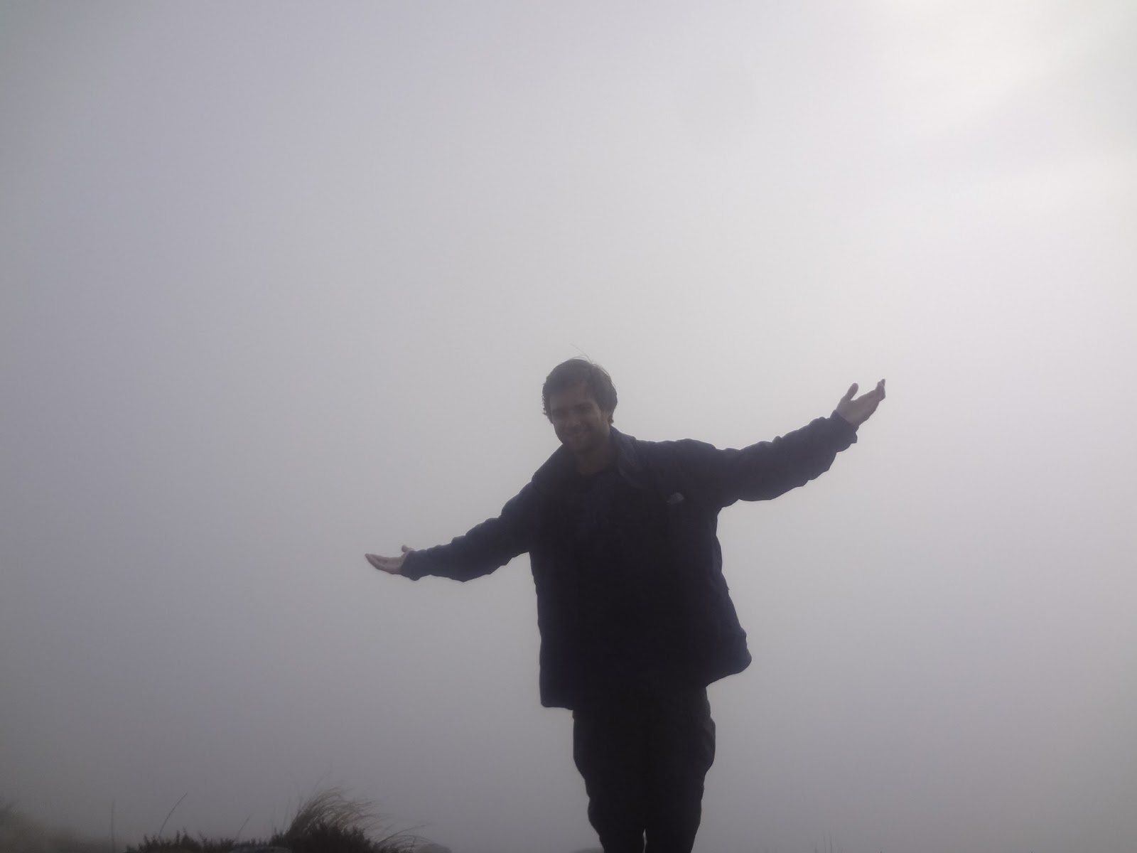

The trip to the
summit veered off of the main trail, and when you got to the top, you
could look out on a sea of clouds, broken every so often by the
jagged mountain peak of some range in the distance. We're in heart of
Fiordland now, and what a jaw-dropping treat it would have been to
have seen the extent of the valleys and summits in a vast network of
wilderness. But at least it wasn't raining.


The road bumped and
dipped onwards, over a saddle that probably had a sweet view just
past the blanket of fog. Lunch today was at the emergency shelter,
where you'd have to be pretty desperate if you had to use the toilet:

Vegetation was
sparse and coarse along the saddle, until you climbed up another hill
to a second emergency shelter and then started the main plunge of the
day. Just as clearly as you cleared the bush line going up, you were
all of a sudden right in the thick of it again. The word that
instantly came to mind was a hollow, a deliciously Gothic word
suggesting heavy, damp fingers of fog enveloping ancient and gnarled
tree branches heavy with old man's beard. If the weather inhibited
things on the mountains, it worked down here.


Funny thing was,
because you couldn't see off in the distance, you could actually
focus on what was around you. And with a thousand little pinpricks of
dew everywhere, the glow of spider webs or berry bushes was pretty
neat, and something that you'd be liable to pass by on a finer
afternoon.


Over the course of
a few hours, you drop about 1000m, with the forest thickening around
you and the coarse stubbly grass replaced by lush ferns. This is why you shouldn't even think about doing the Kepler clockwise – this whole stretch was a steep downhill, and to have to climbed up rather than down would have been a lot more of a struggle. Here's an
obligatory complaint just the same: my bags were slightly lighter on the second
day, but all the trudging downhill was a clop-clop-clop concentrated
solely on my skinny white boy shoulders.


The Iris Burn Hut
sits at the base of a valley, alongside the Iris Burn river. The
cloud that had immersed me at 1400m was now a solid ceiling above the
hut. After slinging off my pack, I wandered back through the woods,
to the Iris Burn Falls a short ways upstream.


After another
safety talk beneath dim hut lights, the ranger gave us a hint about
the virtues of a midnight sojourn. Apparently, only a small
percentage of Kiwis (the people) have seen a kiwi (the iconic,
endangered, flightless bird) in the wild, but there are a few around
the Iris Burn Hut. The chances of actually seeing one are still rare
– they're nocturnal, and scared off by light, but they do make a
big rustling in the bushes (they're not exactly graceful creatures).
At the very least, their repetitive calls are easy to distinguish
from other birds.

I wish I could say
that I went out and had a kiwi walk out right in front of me, but no
such luck. I'll have to visit a zoo before I go home. However, I did definitely hear one (at least two,
actually, since the male and female calls are different and I'm sure
I heard both).
(iii) Iris Burn
Hut to Moturau Hut (16.2 km)
A lot of people on
the Kepler Track actually ended up going farther than this on the
third day, opting to get a shuttle from Rainbow Reach (an hour and a
half past the Morurau Hut) back to Te Anau and finishing today. I
hadn't even considered this route, and was already booked into the
third hut, so I had a leisurely stroll through the forest today. The
clouds cleared early (what a day this would have been up Mt.
Luxmore), and other than a few small hills, the path was an
uninterrupted stroll through the woods.

For the most part,
anyway. This is New Zealand, after all, so you need to take their
warnings very seriously:

The Iris Burn,
slowly trickling alongside the path all day, eventually flows into
Lake Manapouri, the second deepest lake in New Zealand and a nice
postcard picture finish, with the sun shining and the mountains
wrapped around it. I made it to the Morurau Hut in the early
afternoon, and found that our overall group (everyone is moving at
their own pace, but the huts are the congregating point) had shrunk
to about half a dozen people.
The lake was chilly
for swimming (the ranger did, but they're a different breed of human
altogether), but the beach made for a perfectly lazy place to lay
down, letting my body soak in the unspoiled glamour of the New
Zealand wilderness and my mind drift off to the Salinas Valley in
California.


And lo, the sandfly
repellent came out. Had to. These pesky, miniscule nippers are the bane of
existence on the west coast of New Zealand, and everyone who visits
here has horror stories of the welts and bites that itch for days
afterwards. Stand still for too long near the water and you're bound
to be swarmed, and even a greasy citrus sheen on my arms and neck was
futile to completely keep the brutes away.
Despite being
dubbed the party hut because the solar lights stay on until 10:30,
after a beach stroll to gaze up at the stars, the Moturau Hut was
quiet just past 9:00. The final stretch was coming up.


(iv) Moturau Hut
to Te Anau (17.5 km)
There was a cloud
cover on Friday morning, but still no rain. Meanwhile, they were
calling for snow above 700 m, so I was glad enough to be heading back
to civilization. More than that, I was tired – I was getting plenty
of sleep in the huts, but the constant go go go was starting to wear
on me. The Kepler Track is a good introduction to these multi-day
hikes, and I figured out a lot about my own limitations and how to
prepare myself for a different wilderness challenge, particularly if
the huts aren't as well maintained and the trails less obvious (one
tramper called the route of the Kepler a highway compared to some of
the other walks in the country, where you only have cairns to guide
you).
The day was another
long one, but not particularly challenging as it went through more
low-lying forested areas once you left the side of Lake Manapouri. A
few skittish deer ran across the track at one point, and the melodic
songs of small birds was an ongoing orchestration.
One little detour
from the main track was out into a wetland area, appearing as a
sudden break in the trees. Sweet as – there weren't any ghostly
faces peeking up from the peat, but this was the same Dead Marshes
from The Lord of the Rings.


Back to the forest,
the water sounds slowly came gurgling back, first as a little stream
and building momentum as the trail came up along the banks of the
Waiau River, flowing from Lake Te Anau to Lake Manapouri.

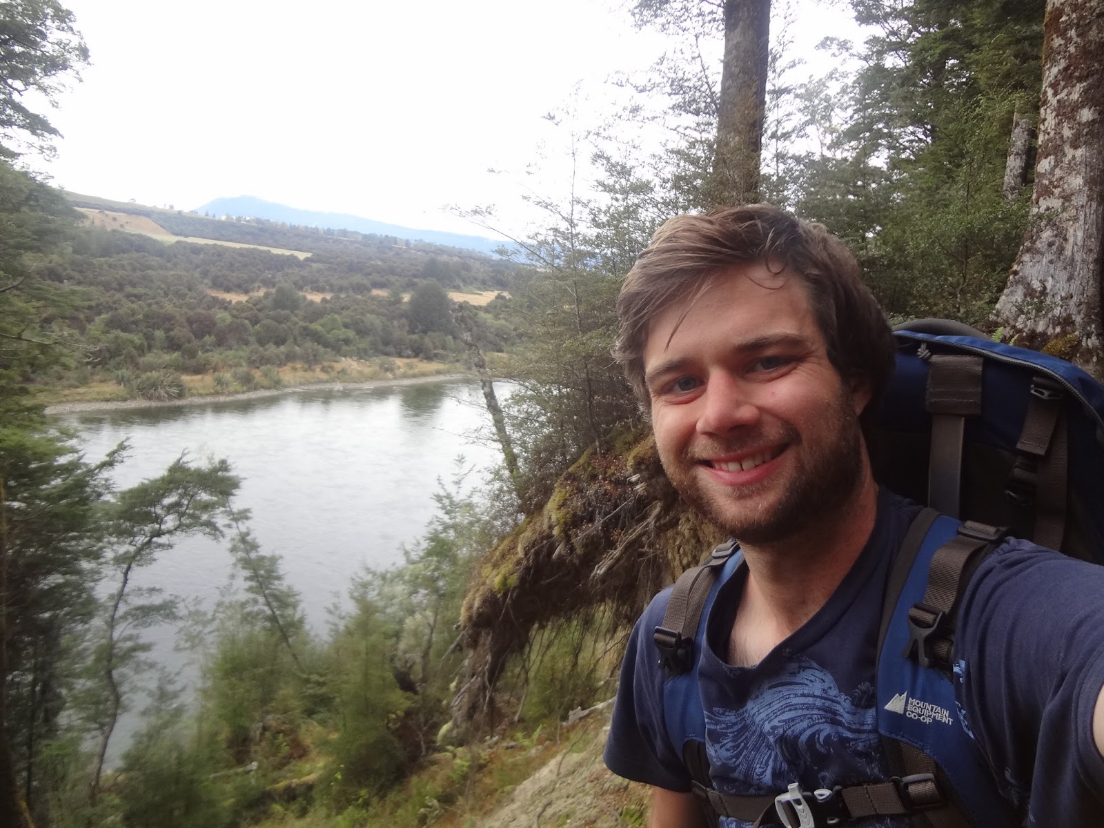
The wide, shallow
river is a popular spot for trout fishing – not to mention that it
too plays a part in The Lord of the Rings as the Great River
Anduin. I'm not sure if the spot where I popped down to scoop up a
handful of cool blue water was the place where Frodo and the
Fellowship parted ways, but I figure it was close.


After passing the
bridge to Rainbow Reach, I was about ready for the walk to be
finished and to get a hot shower. Another long stretch of beech
forest finally led back to the shores of Te Anau and the control
gates that mark the start of the Kepler Track. And what a sight it
was for sore eyes in the bush for four days.


Autumn came with a
vengeance while I was gone, with a chill in the air and yellow leaves
all over the place. I had a moment, on the drive from Invercargill a
few days ago, where I wondered if I'd actually learned anything worth
learning on this trip – I think, though, it takes looking back to
see how far you've come, and now I'm only a few days into my 24th
year and I can already see changes happening. Last night was a
comfortably crowded rest back at Des's, with five surfers from
different nooks in the world and a cushy mattress on the floor for me
to lay my sleeping bag.

It comes back to
the pounamu though, doesn't it – the journey of the
individual, the trip through the woods for four days on your own (not
to mention the trip through New Zealand on your own), is a great
thing. You need to be comfortable in yourself, but complete
self-reliance can be a lonely state – at the end of Into the
Wild, after isolating himself for months in Alaska, Chris
McCandless realizes, too late, that happiness is only real when
shared.
That's something
worth going to the ends of the earth to figure out. And at 24, it's
nowhere near too late.
Cheers,
rb
PS I took a whole pile of pictures that would have crowded this post more than it already is. You can find the lot of them here.
PS I took a whole pile of pictures that would have crowded this post more than it already is. You can find the lot of them here.
What a fantastic journey Ryan and very eloquently expressed. In spending 5 days with you and chatting profusely I think you will find that this "journey"s insights will reveal themselves for a long time yet to come. It was a great pleasure to spend so much time with you on an event I am sure you will find formative in the future cheers Rory .. Am sure there is much more to come!
ReplyDelete