I can't remember where I read that the
drive from Queenstown to Glenorchy, a 50 km stretch along the
mountains and the lazy S-bend of Lake Wakatipu, is one of the best
day trips in New Zealand – maybe I made that claim to fame up.
Whether by official consensus or not, I bet it's still high on that
list.
An autumn sun was burning off the
morning frost when myself and Alan set out from Arrowtown on Saturday
morning. The sky was crystal clear over Lake Hayes, but we still made
sure to be on the road early, with a weather forecast of heavy
clouds, rain, and even snow, if you got high enough.

It was as if a veil was waiting for us,
just beyond Queenstown. You could see the sun like a dangling
lightbulb in a smokey bar from the 90s – it was up there, but the
fog wasn't ready to be burnt off, not just yet. The winding road
(only a few decades old, and even more recently tar sealed for the
first time – before that, the only way to Glenorchy was by boat)
was much more deserted than during the busy summer months, but every
now and then it peaked out from behind the cumulus curtain to give a
view of the snow-capped mountains that was pretty impressive, no
matter the season.
Glenorchy isn't a flashy tourist town,
but that's still the main driving force behind it. River treks, Lord
of the Rings 4WD tours, and
cafes are the main spots to visit, unless you're just passing through
on your way to do some tramping – the Routeburn Track, one of New
Zealand's Great Walks, starts (or ends) about 20 km outside of the
small town, coursing through beech forests and mountains to end up, 4
days later, north of Te Anau. We went down along the docks at the
northern tip of Lake Wakatipu, right in the thick of the fog.
Fortunately,
Glenorchy isn't the end of the road. Sure, it's so-called tiger
country beyond, but we had a tank of petrol and time to kill before
the sun decided to stop being contrary and brighten up the area.
Northward we went, along a dirt road that not too many casual
visitors get to see.


I've been in New
Zealand for three and a half months, but I've only now, officially,
been in Paradise.

Creeks crossed the
road at half a dozen dips, the sun igniting puffs of mist and curling
them as if from smouldering ash at the feet of the mountains. Hang
onto your seats – besides for half a dozen tourists and a few
fields of sheep, this section of Mount Aspiring National Park (New
Zealand's third biggest) is isolated, other than you and the big
rocks.


The drive ended
along the wide, shallow valley of the Dart River. The sandflies were
out, and their arrival was prophetic – the rain started pecking
just as we got an eyeful of the sprawling countryside up here, at the
literal end of the road.


After a lunch stop
back in Glenorchy (homemade pies, what else?) and still outpacing the
nasty weather behind us, the day was a whole lot clearer, granting us
a much nicer view back along New Zealand's longest lake, not to
mention the sizable Pig Island and Pigeon Island, which were
completely concealed in the morning mist.


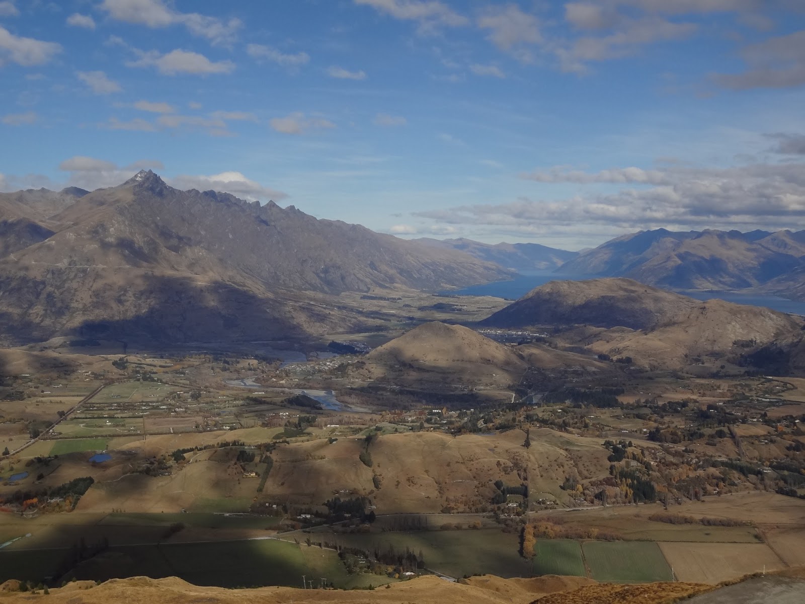
Cruising
back through Queenstown, we made a vertical detour. Up, up, up,
1191 m by the GPS – I'd count on it being the highest I've ever
been in a car, to the base of the Coronet Peak ski field. The lifts
climb an additional 500 m, and right now people might be mountain
biking and paragliding from these heights, but it won't be long
before the snowguns get fired to life and the skiers start lining up.
Up here, you've got a panoramic view of the sprawling valley, from
Queenstown to Arrowtown and the Crown Ranges, on as far to the bottom
of Lake Wakatipu and Kingston. Coronet Peak is one of three ski
fields in the immediate area – the Remarkables looks across the Wakatipu Basin, and the Cardrona Alpine Resort is en route to Wanaka.
I wonder where in this country I'll be, once the snow settles in?


Heading back down to the valley, we skirted the gravel road heading
on to Skippers Canyon, just over the back hills. Remnants from the
gold era are hidden along this off-road passage along the Shotover
Valley where rental cars aren't allowed.

By now, it was high time for fish and chips and pints at the Tap.
Sunday
morning, the weather ended up coming down in buckets, like they said.
I met up with Rory for a breakfast coffee in Arrowtown, getting
pointed in the direction of Ray Wade's Studio. A
local self-taught jeweller, Ray
invited me in for a tea and jam-filled Kisses (straight from the
Edmonds Cookery Book, a Kiwi staple that happens to be the biggest
selling book in this country), showing me how he does some of his
woodcuts, polishes his gems, and identifying the pounamu
around
my neck as Inanga,
the Maori word for tiny Whitebait fish. Lamb roast garnished with
pumpkin, kumara, and parsnip for dinner – another Kiwi staple.
The
day was overcast but decent on Monday morning, so I decided to take a
look down the road to Central Otago (take everything I say with a
grain of salt – it was less than a week ago that I said I didn't
have time to check out these parts). I hitched a ride with a local
couple as far as the Arrow Junction, where the country road joins
into Highway 6, and a Chinese couple on a whirlwind, two week tour of
New Zealand's South Island, brought me to Cromwell, via a dangerously
winding, narrow stretch of road along the Kawarau River. As if to
reinforce that this country of sepia hillsides demands your
attention, we passed a “Slow Down, High Crash Rate” sign –
remember this bit of trivia, and place it on your mental map of the
area, because it will
be
important.
Cozy Cromwell, positioned right where the Kawarau meets the Clutha
coming down from the north, was once called the Junction because of
this moist meeting place, and it was the gold that brought people
here back in the 1860s. Nowadays, it's a fruitbowl hotspot, with
wineries and orchards dotting the fields around Lake Dunstan, a
man-made lake that flanks the town and originally grew as a result of
the Clyde Dam in the 1990s (before that, the lake was a deep gorge
with train tracks and a river some 40 m below the current level).

Much of the old town was destroyed and replaced by a modern
development, but a little chunk along Melmore Terrace was
reconstructed by Old Cromwell Incorporated.


The leaves are falling, littering the ground beneath bare and
withered grapevines in front of mountains with a nice white toupee.
It looks a lot different from when I arrived in Marlborough at the
end of January.


A Kiwi from Queenstown who manages a sawmill in Alexandra picked me
up along Highway 8, making a detour through Clyde to show me the
imposing dam that churns out a heap of electricity for the national
grid. We get talking, like you would, about what I'm doing down here.
“You ever work in a timber yard before?”


I had to do a bit of a double take at my person. Jeans with factory
rips about the knees, clean fingernails, and if you listened
carefully you could probably hear Katy Perry coming through on the
headphones in my backpack. Instead of saying, “What do you think?”
I just said, “No.”
“Well,
you don't really need it,” he said, giving me his cell phone number
and offering me a job that's literally better paid than anything a
university degree and months of frustrating job hunting ever turned
up. Who knows – I could end up back here soon enough. Or not. This
whole thing is a tiki tour after all, not just the past few days but
the whole kit and caboodle, and whatever happens happens.
When
I ended up in Alexandra, it was just past 2:00. This spot is a bit
bigger than the other stops along the road these past few days, with
all the bells and whistles like box stores and a clockface in the
hillside. Still, there's a historic core here – a bridge over the
Clutha runs right next to crumbling piers from the old one
from the 1800s, and
there's the Otago Central Rail Trail.


At 150 km long, the walking/biking/horse riding track is the longest such trip in New Zealand, following the path that the Otago Central Railway ran between Middlemarch and Clyde from the 1920s until 1990. A
little strip, about 8 km, passes between Alexandra and Clyde. I
didn't have a bike, but for that short distance and with the sun
still a ways over the horizon, I decided to walk it. The terrain
wasn't the most invigorating in the world, but the flat gravel road
looked upon plenty of mountainsides and isolated little farms.
Nothing wrong with a little stroll along the rail bed – I felt like
I should have had a bamboo fishing rod slunk over my shoulder, on my
way to the creek with at least one friend wearing overalls.


When I came to Clyde, a woman gave me a lift to the top of the hill
just outside of town, where I caught a ride with a few Chinese
tourists in a campervan. Things were going along smoothly, and when
we came to the lookout before Cromwell and pulled over, I assumed the
cameras were about to go nuts.

Sure, we got a few pictures. But the main reason for stopping was
because of the police with his sirens flashing.
Even
the police in this country are friendly. The Kiwi cop seemed to
legitimately felt bad for pulling these people over, even though
other drivers had been calling to complain about their driving all
afternoon. Actually, scratch that – they'd been complaining for
days,
from
Milford to Dunedin.
In the short distance since I'd joined them, I hadn't noticed
anything erratic, which is probably why I didn't jump out right then
and there. But I watched, knuckles whitening, as he tried to explain
how you don't overtake if you can't see ahead of you and how you need
to slow down going through towns (“50 kilometres . . . that's five
zero. Five. Zero.”). I could see the heads nodding just as clearly
as I could see the language barrier and the words bouncing
haphazardly in all directions.
“Oh, how are ya mate?” he said when he saw me in the backseat,
and I could see the relief flood into him upon seeing a native
speaker. I followed him when he went back to his car to write the
ticket.
“So, umm, is it legal for me to drive the rest of the way?”
He thought for a minute. “It would be a lot safer,” he said, “but
if you got into an accident, you're not insured.”
So we came up with a compromise – I sat in the front seat and kept
an eye on things. Like speed, and telling her to pull over because
her headlights clearly weren't on and the last thing I wanted was her
fumbling with switches and levers as we drove down the highway. The
same highway (remember?) with a high rate of crashes.
Now
that you're sufficiently worried about my well-being, let me say that
after that fiasco, the drive back was much safer. The middle-aged
woman taking driving lessons from a snot-nosed Canadian kid had
gotten an overly polite dose of the fear of God put in her, and every
passing lane saw a slew of cars whisk past us. Just as dusk was
settling in, we made it back to Arrowtown – in one piece and
everything.

This morning is bright and sunny, but there was even more snow
overnight – the mountains have a full blanket of snow, not just a
skirmish. The same mountains that, if all goes according to plan,
I'll be heading over this evening, to make my way north to Wanaka for
a few nights, to see the other side and keep moving. Until I go and buy a winter coat (I threw out a pair of shorts during this stay), that's the only
guaranteed way to keep from freezing.
Cheers,
rb
No comments:
Post a Comment